Saturday, May 3, 2008

The Mt. Hood Freeway (I-80N) Facts and History Page

The Mt. Hood Freeway was a polarizing project of the 1970's where inner city people took a stand against an expressway that would have benefited the outer suburbs and the City of Gresham while destroying their SE Portland neighborhoods


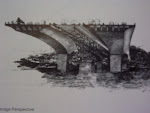
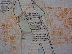
The path of the freeway is shown below with the properties highlighted in yellow for acquisition and destruction. The freeway would have started at the east end of the Marquam bridge, coursed in a SE direction towards Division Street (following the railroad tracks on the north side). Then cut an 8-lane swath where SE Clinton Street is today. At 52nd Ave, the freeway would have made a 45 degree turn towards SE Powell. From here, it would follow an 8-lane path just to the south of Powell to a junction with I-205. A spur from this route would have connected to a replacement for the Ross Island bridge. Approximately 1500 homes and businesses would have been destroyed.


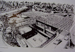
The Moses freeway plan was revised as part of the Portland Planning Division 1966 developmental plan. Red indicates existing freeways. Green indicates freeways never built

Friday, May 2, 2008

The Mt. Hood Freeway


The Five-Mile Asphalt Monster
The Mt. Hood Freeway was an 8-lane, open-cut, superhighway that, if constructed, would have carved it's way through SE Portland from the eastern approach of the Marquam Bridge to an interchange at the I-205/Powell junction. From there, an additional stretch called the Mt. Hood Extension, would have continued east (aligned approximately just south of Powell Blvd/US 26) to Gresham. A third section would run between Gresham and Sandy. The freeway project would have destroyed local neighborhoods and was scrapped in the mid 70's due to "grass roots" opposition. Federal highway funds were redirected and used to build the MAX light rail system instead of the freeway and Portlanders took an important first step in curbing cars in favor of public transportation.

The Highway Man

In the beginning, there was Robert Moses, an urban planner from New York, with a reputation for innovative freeway networks. Moses had the benefit of a spectacular education. He graduated from three colleges: Yale, The University of Oxford (United Kingdom) and had a political science degree from Columbia University. He was an idealist who could get things done his way. He rose to power directing infrastructure projects through the New York State Government.

During WWII, the City of Portland commissioned Moses to plan their transportation system for the future. Moses visited the Rose City and fashioned his plan. He envisioned a central ring around the city with network of different freeways. Over time, his plan was changed to include 12 specific expressways. These included the following: the Banfield freeway (currently I-84), the Mt. Hood freeway, the Baldock freeway(currently I-5), the East Bank freeway(I-5 section between the Marquam and Fremont bridges), the Sunset freeway (I-405), the Stadium freeway (I-405), the Industrial freeway (Hwy 30/St. Helens/I-505), the Delaware freeway (aka the Minnesota freeway), the Fremont freeway (aka the Prescott or Rose City freeway) , the Sellwood freeway, the Johnson Creek freeway, I-205 freeway (the East Portland freeway), the 52nd Ave freeway, etc. These freeways all connected allowing swift travel throughout the city. One of the keystones in this freeway web was the Mt. Hood freeway. Planning of this expressway went through the normal channels during the 1950's and 60's. It seemed inevitable that the southeast sector would be stamped (like a cookie cutter!) with this long planned freeway. And the SE residents would allow this for the good of the city (or Gresham?)............Right? Not so fast, my friend.

The People vs. the Mt. Hood Freeway

In 1969, Al and Kayda Clark were a young, hard-working couple living in SE Portland. At this time, The Oregon Dept. of Transportation began buying houses to clear the way for the freeway. Some of these homes were actually being torn down as they were acquired (creating the Ivon Street Community Gardens and Piccolo Park). This action resulted in a reaction by the local SE neighborhood residents. The Clarks along with others formed the Southeast Legal Defense Team to fight the construction of the freeway through their neighborhood. Over the next five years, they battled the freeway in court and at every turn. Eventually, the Portland City Council and the Multnomah County Commission both voted the freeway down. The anti-freeway sentiments were also strengthened by the Governors Task Force in 1973 and by a Environmental Impact Study performed by Skidmore, Owings and Merrill that projected the freeway project as a failure. The study found that the Mt. Hood would not relieve congestion and would be obsolete by the time it was finished. In 1974, a series of rulings against the freeway led to cancellation of the project. It was a stunning blow. The local residents and business owners had successfully stopped the freeway. The freeway proponents tried again in 1975 but were unsuccessful. By defeating the freeway, Portland positioned itself to change the way it would look at the gas-powered car for the rest of the century and beyond.

Honor Roll


The following groups and people deserve mentioning for their efforts to in helping defeat the Mt. Hood Freeway: City Commissioners Lloyd Anderson and Connie McCready, County Commissioners Don Clark and Mel Gordon, STOP (members: Ron Buell, Jim Howell, Charlie and Barbara Merten, Steve Schell), SE Legal Defense Fund (Al and Kayda Clark), OSPIRG (Steve McCarthy), Bing Sheldon, Charlie Sax, PACT, David Hupp, Ernie Bonner, Steve Dotterer, Ernie Munch, Doug Wright.

Counterpoint


Every story has two sides. The evidence shows that many people wanted this freeway to be built. Many still want the freeway today. In 1974, the freeway meant jobs for people, many east county residents in the suburbs could use this freeway and would have voted yes if the Mt. Hood had been put on a ballot measure. The Federal government, multiple labor unions, ODOT, the City of Gresham (especially prominent land owners and developers), Portland City Commissioner Frank Ivancie and the downtown Portland business owners were asking the same question: why kill a perfectly good freeway? And there was $500 million in federal funding that had been allocated for the freeway hanging in the balance. In the end, a compromise was reached. The Mt. Hood was dead. The federal money would be redirected to build the east side light rail. Powell Blvd and the Banfield Freeway would both be improved (widened) and the freeway supporters would get to build The East Portland Freeway (I-205). There had been serious talk of killing this freeway as well.

The Pendulum Swings Back and Forth

The story of the Mt. Hood Freeway is one of how neighborhoods banded together to defeat an invasive expressway and redirect the concept of moving people in a different way through mass transit. There is a twist here: In 1958, one day after Portland's first freeway opened, was coincidentally, the day that Portland's last interurban electric trolley stopped running. The automobile and the freeway had put the electric train out of business. Yet, less than 20 years later, people rejected the car and freeway concept in favor of the electric train! What if in the near future, technology brings us a pollution-free car that runs on a cheap, "green" fuel? Could we see an attempt to bring back the Mt. Hood Freeway? Don't remove those stubs from the Marquam bridge just yet.

Mt. Hood Freeway Time Line

1943 Robert Moses unveils his freeway plan to the City of Portland
1955 Regional freeway plan revived; freeways and bridges named. Freeway on the east side dubbed "Mt. Hood Freeway"
1956 Federal Highway Act boosts spending for building freeways
1958 The 13-mile Banfield Freeway is dedicated and opened
1961 Baldock Freeway completed to downtown Portland
1962 The Mt. Hood Freeway is formally submitted for inclusion into the US interstate highway system as I-80N
1966 Marquam bridge is opened. The upper and lower, east ends are built with stubs for connection to the Mt. Hood Freeway (one lower stub still exists)
1966 The Minnesota Freeway (I-5) opens linking Marquam and Interstate bridges
1969 ODOT, the City of Portland and Multnomah Co. approve the Mount Hood Freeway route
1969 Mount Hood Freeway funded (90% federal and 10% state and local)
1970 Environmental Protection Act and The Clean Air Act bills are passed
1970 Neil Goldschmidt elected to Portland City Council
1971 STOP formed by Ron Buell and Jim Howell
1972 Neil Goldschmidt elected Mayor of Portland
1972 Complaint filed in US District Court stopping freeway pending environmental study
1973 Federal Aid Highway Act passed with Interstate Transfer Division (allows freeway money to be shifted to public transportation projects)
1973 Skidmore, Owings and Merrill release environmental impact study on the Mt. Hood Freeway
1973 Fremont Bridge opens
1973 OPEC oil crisis with gasoline rationing
1974 February, Federal Judge Burns rules against freeway
1974 February, Multnomah County Commission repeals freeway approval
1974 July, Portland City Council voids approval of freeway by a 4-1 vote (Ivancie is the lone vote)
1974 November, Governor Tom McCall deletes freeway from ODOT
1975 Mt. Hood Freeway formally withdrawn and funds reallocated
1978 Portland Transit Mall opens
1978 Portland Light Rail is approved
1981 Construction begins on the 15-mile starter line for the Portland Light Rail
1986 Light Rail named MAX and begins running

References

Robert Moses, Portland Improvement, Nov 10, 1943, for the City of Portland, Port of Portland and Commission of Public Docks

The Oregon Journal, April 6, 1958

The Oregonian, June 29, 1955

The Willamette Week, Highway to Hell, WW, March 9, 2005

Gregory L. Thompson, How Portland's Power Brokers Accommodated the Anti-Highway Movement of the Early 1970's: The decision to Build Light Rail, vol 3, 2005,

StreetFilms: The Defeat of the Mt. Hood Freeway, 2005, Clarence Eckerson

Skidmore, Owings & Merrill, Deleuw, Cather & Co. , I-80N Environmental Study, July, 1973 for ODOT