Mount Hood Freeway Interstate 80 North Mt. Hood Freeway I-80 North I-80N
Future Bridge
Commuters may have been pleased with the carrying capacity of this 10-lane wonder if it was ever built
Marquam bridge stub
This unused ramp was designed to link to the Mt Hood freeway
Should they have completed the Mt Hood Freeway?
"This freeway will hurt the people inside the city to the benefit of those outside" Com. McCready
Was this the future for SE Powell Blvd and the I-205 freeway?
The Ross Island bridge (right), Marquam bridge connectors (left) and the Mt Hood Freeway all converge on SE 15th and Ivon St.
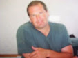
Neil Goldschmidt was the Mayor of Portland from 1972 thru 1979. He led the freeway revolt and helped transfer the federal money to build the eastside light rail (MAX). Unfortunately, he was also having an affair with a 14 year-old girl at the same time.
The Father of Freeways Past and Present: Robert Moses
The Marquam Bridge (circa 1966) was built with the Mt. Hood Freeway as the next logical step
The Marquam was not big enough however, to handle the future traffic volumes generated by the Mt. Hood Freeway. A replacement for the Ross Island Bridge or tunnel under the Willamette River was already under consideration in 1974.
Tunnel Plans
1958 Newspaper article about the future freeways in Portland
Projected carbon monoxide levels for the freeway neighbors
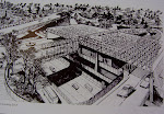
Artist's conception of the freeway
Oregon Governor Tom McCall
He always tried to do the right thing for Oregon. He appointed Neil Goldschmidt as Chairman of the Governor's Task Force in 1973
Looking down on the upgraded freeway bridge and the I-80N
This gives an idea of the freeway's width as it cuts through the SE
Freeway Bus Station
Metro Area Express or MAX
MAX is the sixth most ridden light rail system in the US. MAX runs on 44 miles of track and serves 64 stations
Portland's original MAX: the interurban electric train
In 1912, the electric train serviced 250,000 people with 22 miles of track and 24 stations